Features
Nilwala salinity barrier: Another white elephant

by Matara District Farmers’ Federation
We are writing this in response to the article “The Salinity Barrier and Nilwala Floods: Clearing up Misconceptions by Dr. R. Galappatti, Chairman of Lanka Hydraulic Institute, published in The Island on 01 Jan., 2024.
As farmers, we accept that providing drinking water to the people should be considered a priority and that it is a basic human need. We also accept that after obtaining water for drinking, if there is any excess, it should be used for agricultural purposes. Accordingly, it has been mentioned in the environmental assessment report that the flow of the Nilwala river through the Matara District is sufficient to supply drinking water even during the dry season, and that there will be a surplus even in the year 2045.
The report says that in 2045, the amount of water obtained from the river by the “National Water Supply and Drainage Board” will be 114,000 cubic meters a day. If the withdrawal amount is calculated as a percentage of the water flow in the river even during the dry season with minimum flow, it is almost 55 %. The environmental assessment report has said the removal of that amount will not cause any disturbance to the ecological flow of the river.
The obstacle to continuous water supply during the dry season is the space that is prepared to drain the water by the high flow of water in the river during the rainy season; during the dry season the flow is reduced. Then salt water enters the river during high tide conditions. Therefore, the salinity barrier has been constructed to prevent saltwater from entering the river.
Simply to avoid this situation, the construction of the salinity barrier should have been planned in such a way that the entire cross section of the river could be fully opened during the rainy season and closed thereafter.
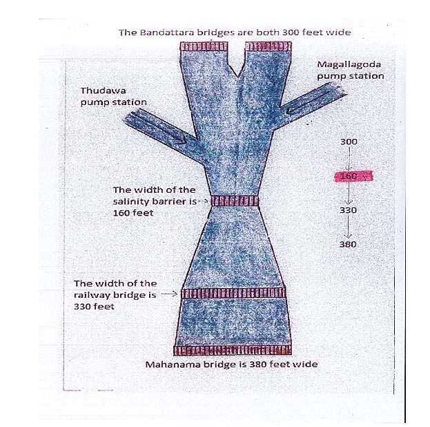
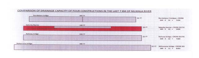
But the cross section of the river at the point where the salinity barrier stands has been greatly reduced. Questions about this have been posed to the engineers of the “Irrigation Department”, “National Water Supply and Drainage Board” and “Lanka Hydraulic Institute” at several meetings attended by their officials. But they have gone unanswered. Therefore, we compared the cross-sectional areas of the constructions above and below the salinity barrier with the area of water flow through the cross-sectional area of the salinity barrier. The salinity barrier has reduced the width of the river to more than 75% of its original size in comparison to other constructions. (See diagram 1 – the width is reduced and diagram 2 – cross-sectional area is reduced.)
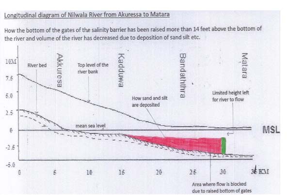
The worst damage is reduction in depth. The bottom of the gates of the salinity barrier is raised more than 14 feet above the original bottom of the river before construction. Because of this, silt and sand have been deposited more than 15 km upstream from the location of the salinity barrier and the volume of the river has decreased. See diagram 3.
As a result, the river overflows during heavy rains, submerging many areas including paddy fields, marshy lands and roads.
According to the cross-sectional diagram of the salinity barrier included in the environmental study report, that has reduced the depth of the river by more than 14 feet. This mistake cannot be easily rectified. See diagram 4
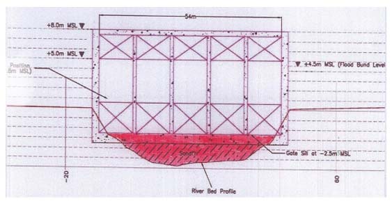
This depth reduction is a huge mistake and the difference between the depth reduction, i. e. the previous bottom of the river and the concrete placed at the bottom of the gates has been reduced /changed in the cross-sectional photograph of the salinity barrier published with the aforesaid article in The Island. (See in figure 5)
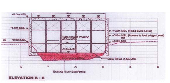
We would like to remind the President of Lanka Hydraulic Institute Dr. R. Galappatti that such incorrect data mislead the public. (See Diagram 5: The diagram (in the environmental assessment report), which has been modified.
Some of the factors neglected in the construction of this salinity barrier are as follows:
01. This construction has been planned ignoring the Nilwala Flood Protection Project, which is the biggest development project implemented in the district along the River.
02. The dimensions (space/volume of water flow) of other structures built across the river in the final reaches of the river (up to 7 km from the mouth of the estuary) have been ignored.
03. Topography of the area has been ignored.
04. The behaviour of rainfall in the catchment area of the river has also been ignored.
05. None of the recommendations mentioned in the technical study report obtained during the environmental study has been taken into consideration. This is a very serious situation.
The Central Environmental Authority (CEA) is also responsible as it did not follow up properly until the completion of the project’s design and construction. Farmers have informed the CEA on several occasions for the past two years or so. On observing the behaviour of the National Water Supply and Drainage Board’, we could see that on several occasions, it acted without even considering the instructions given by the CEA.
06. The Memorandum of Understanding signed between the “Irrigation Department” and the “National Water Supply and Drainage Board” has been violated on several occasions due to the incorrect design prepared by the Lanka Hydraulic Institute.
07. The “National Water Supply and Drainage Board” did not implement the decisions made at the meetings during the construction of the salinity barrier and the recommendations made by the CEA and the “Irrigation Department” on several occasions so all opportunities to rectify this have been missed.
The irrigation control area encompassing “Kiralakele”, “Kadavedduwa” and “Kadduwa”, declared as protected has become unprotected due to the neglect of the Nilwala flood protection project. Paddy lands, roads, houses and lowlands in the area up to “Akuressa” are now submerged even during light showers.
It has been recommended in respect of the unfinished Nilwala flood protection project that action be taken to remove the obstructions including stones on the bottom of the river in the area above the mouth of the estuary, create a bypass canal through the Eliya Kanda area and take necessary measures to ensure a quick flow. The salinity barrier has been a major obstruction to the flow of the river.
The neglect of the Nilwala Flood protecting Project has placed the Matara town at great risk. Due to the salinity barrier blocking the flow of the river, if 400 mm of rain falls within 48 or 72 hours in the upper catchment areas, the flood control dams will be in danger of breaching, and the entire Matara town will be submerged in such an eventuality.
The lower valley of the river from Akuressa to Matara is a plain. The length of the river from Matara to Akuressa is only 32 km. The slope of this plain area is two to three metres. Therefore, during the rainy season, this lower valley is affected by floods because the rainwater from the upper shed area flows rapidly to Akuressa, but beyond Akuressa, it flows slowly to the sea.
A proper study has not been made of the rainfall in the river catchments. When we look at the past rainfall data for the catchment area, it is clear that rainfall increases annually. We believe that if this information had been considered, the salinity barrier would not have been built blocking a part of the cross section of the river.
In addition to the disastrous situation caused by non-drainage during the rainy season, when the gates are closed to prevent seawater from entering to river during the dry season, the water level above the salt barrier is more than 400 to 500 millimeters higher than the downstream, so the drainage of water from the Gravity outlet gates of “Kiralakele” and “Kadawedduwa” farming area stops and both protected irrigation-controlled areas become inactive.
This situation has come about due to the non-implementation of the recommendations mentioned in the technical study report made by the CEA through the “Central Engineering Consultancy Bureau” as stated in the Environmental Assessment Report. A construction plan was prepared without considering the MOU signed by the “Department of Irrigation” and the “National Water Supply and Drainage Board”.
Thus, this project has become a complete failure.
What was published in The Island was from the original cross-sectional diagram attached in the environmental assessment report. There has been an attempt to minimise the extent of the reduction of the river depth. See diagram 6
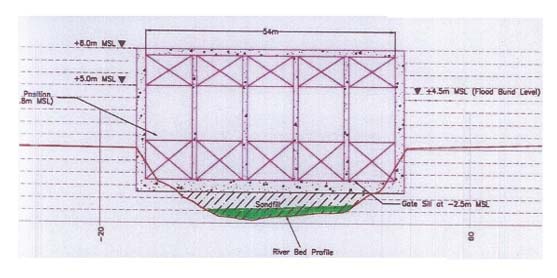
We would like to tell the Lanka Hydraulic Institute that the ground reality cannot be changed by tampering with original plans and documentation and then publishing them in the newspapers.
We know the importance of providing drinking water. If the salinity barrier had been built in a proper manner, that would have helped manage the drinking water problem without adversely impacting the rice growers and the people living in low-lying areas; that’s why we agreed to this project proposal. But due to mistakes by the Lanka Hydraulic Institute, this project has become a failure.
We request the Lanka Hydraulic Institute to realise the destruction caused by the mistakes in the design of the salinity barrier and have a dialogue with us to rectify the errors.