Features
Geological explanation of the recent Earth tremors near Victoria Dam

By J. M. T. B. Karu Jayasundara
Geologically the crust of Sri Lanka consists mainly of metamorphic rocks and to a lesser degree sedimentary and igneous rocks. Rocks in Sri Lanka are subdivided into High Land, Vijayan, Wanni complexes and some sedimentary rocks. However, around the Kandy region there are classical rock types. These can be found in Syncline form in Gadaladeniya, Dumbara and Teldeniya Arena. I like to name these rocks, Arena rocks (also known as Kadugannawa Rocks). The morphological oval shape appearance of Arenas’ can be seen clearly by aerial photography of the area. The Arena rocks consist of low grade (retrogressive) metamorphic rocks of amphibolite and mica (Hydrothermal altered). Evidence shows that the Arena rocks are mainly of igneous (volcanic) origin. The Eastern region of Arena rocks is surrounded by Highland series rocks and the Western region by Wanni series. (Map 1)

It is a geomorphology concept that any river or stream creates a path through the weak zone of rocks or sediment formation.
This is good evidence that the Mahaweli river follows the weak zone between Highland and Arena rocks around Kandy and Pallekele area.
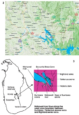
Firstly, the river enters from the Highland series rock region to the southern contact zone of Gadaladeniya Arena, then flows to Dumbara Arena, followed by Teldeniya Arena. (Map 2)
The Mahaweli river follows the weak zone between hard Highland series rocks and soft Arena rocks and it is important to note the nature of the weak zone between these two rock formations. (Map 3)
Secondly, I had an opportunity to map the Pollgolla tunnel in the Mahaweli project for my final year thesis in 1974. Initially, the tunnel excavation was done from Talavinne village to the Mahaweli river and on to the Ukuwela area. The tunnel excavation was mainly done through the Dumbara Arena rocks to Highland series rocks in the Ukuwela region. It was a great opportunity to see the character of the contact zone of Highland series and Arena rocks under the tunnel. During the excavation a large near vertical shear zone was found between the two rock types. The shear portion of rocks were highly weathered to form fine muddy clay. (Map 4)
The Dunuwila village is located above the shear zone. The groundwater above the tunnel in the Dunuwila area drastically reduced and the water was found inside the tunnel. The tunnel excavation work was shut down for a few months. The shear zone can be named ‘Dunuwila’ shear zone.
Thirdly, a large number of vertical shear zones were seen during the mapping of the tunnel within Arena rocks. The shear zones were directly below paddy fields. Most of the paddy fields follow the underground minor shear zones of the three Arenas. Generally, these types of shear zones are not found in the Highland rock terrain.
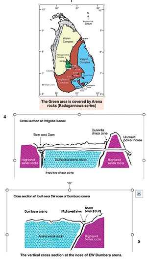

The Dunuwila contact shear zone may extend to cover the area between Highland series rocks and around the Arena rocks to meet the Mahaweli river at the South West nose of Dumbara syncline, near Aluthwatta.
The earth tremor around Pallekele area only occurred recently and the earth movements were felt by the residents of the area. A number of tremors have also been recorded recently on the seismograph of Pallekele. It is difficult to find any other surface scientific evidence regarding the tremor in the region.
I can now make several final conclusions regarding the earth tremor which occurred North East of the Victoria dam. The nose of South West part of Dumbara syncline (Arena) is surrounded by weak shear zone. The Mahaweli river flows through the weak zone. The shear zone can become active any time to create a tremor from its movements, due to the following reasons in the area. (Map 5)
1) River sediment accumulation is greater in the Arena area
2) Regional lateral tension of the rocks
3) Unloading effect due to removing surface materials (Erosion)
4) Water pressure in the reservoir
The inactive shear zone can become active due to one or more of the above mentioned reasons.
And last, but not least, tremors around Pallekele area will not affect the Victoria Dam, if the intensity of the shear movement is minor.
(This article is for general public information rather than academic purposes.)